


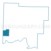
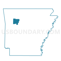
Lee Voting District, Johnson County, Arkansas
About
Outline

Summary
| Unique Area Identifier | 527006 |
| Name | Lee Voting District |
| County | Johnson County |
| State | Arkansas |
| Area (square miles) | 15.95 |
| Land Area (square miles) | 15.88 |
| Water Area (square miles) | 0.07 |
| % of Land Area | 99.58 |
| % of Water Area | 0.42 |
| Latitude of the Internal Point | 35.47452520 |
| Longtitude of the Internal Point | -93.67377540 |
Maps

Graphs
Select a template below for downloading or customizing gragh for Lee Voting District, Johnson County, Arkansas


Neighbors
Neighoring Voting District (by Name) Neighboring Voting District on the Map
- Voting District 3-A, Franklin County, AR
- Voting District 6-A, Franklin County, AR
- Grant Voting District, Johnson County, AR
- Horsehead Voting District, Johnson County, AR
- Stonewall Voting District, Johnson County, AR
- Ward Voting District, Johnson County, AR
Top 10 Neighboring County Subdivision (by Population) Neighboring County Subdivision on the Map
- White Oak township, Franklin County, AR (5,574)
- Grant township, Johnson County, AR (1,377)
- Ward township, Johnson County, AR (978)
- Horsehead township, Johnson County, AR (761)
- Alix township, Franklin County, AR (470)
- Stonewall township, Johnson County, AR (431)
- Lee township, Johnson County, AR (257)